
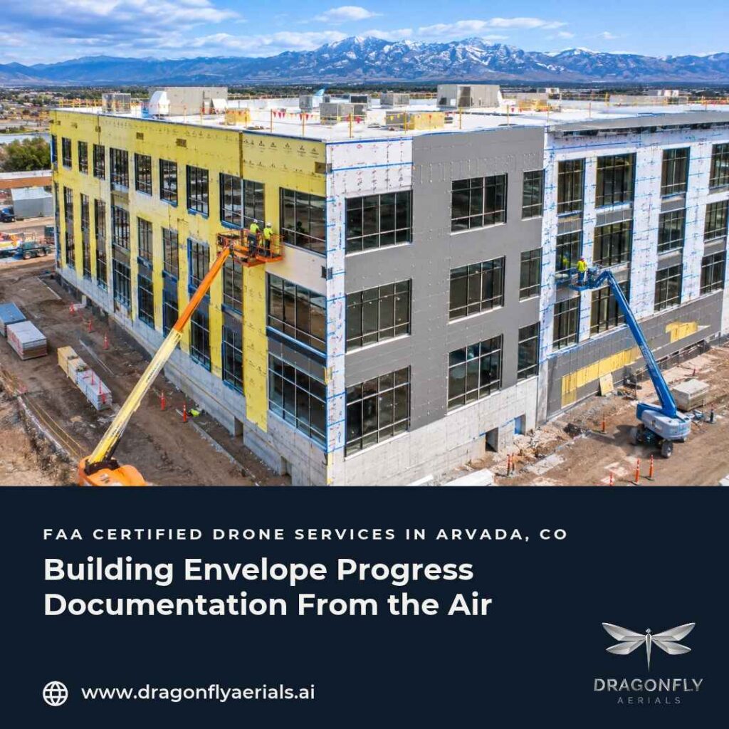
Once the structure tops out, the schedule’s attention moves to the outside of the building. Sheathing, air and water barriers, windows, flashing, cladding, sealant, roofing, and parapet caps all go on in overlapping sequences, often by different crews working for different subcontractors. Each layer covers the one before it. By the time the building looks finished from the street, much of the work that decides how it handles water and air is hidden.
That is why building envelope progress documentation deserves its own plan. This article covers what to capture while the enclosure goes up, how often to fly, and where a drone record fits next to the inspections and testing your contract already requires.
Why the enclosure is hard to document
The National Institute of Building Sciences makes the point plainly in its building enclosure commissioning guideline, published on the Whole Building Design Guide. The enclosure is assembled on site “one piece at a time by many different tradespeople, working for several different contractors with often minimal coordination,” and the work happens in all kinds of weather. The guideline also notes that enclosure performance cannot be verified until the entire building is enclosed, and that getting back to an assembly that is not performing can be very expensive. Its recommended approach during construction includes visually observing the installation of a sampling of the work.
A visual record does not replace that kind of expert observation, and it does not replace field testing. What it does is give everyone on the project the same dated view of what was installed, where, and when.
What to capture at each stage of the enclosure
Sheathing and barriers
Before cladding goes on, capture each elevation with the weather barrier exposed. Overview images of full elevations show where the barrier is complete and where it is still open. Targeted close-ups around rough openings, at floor lines, and at the base of walls show the details that will soon disappear behind the finish.
Windows and storefront
As openings are filled, a repeat capture from the same positions shows which units are set and which are still waiting. That sequence helps later if a leak shows up and the team needs to know which units went in before or after a particular weather event.
Cladding progress
Cladding usually moves elevation by elevation. Consistent-angle photos from repeatable viewpoints make it easy to compare one week to the next and to show an owner or lender how much of each face is complete. Missing or damaged cladding, displaced components, and staining are all conditions that elevation imagery can document, depending on lighting conditions and site access.
Sealant and flashing
Sealant joints and flashing are small details with large consequences. Targeted close-ups can document failing sealant and flashing concerns where they are visible from the air. Anything that needs a hands-on check still needs one. The imagery helps the team decide where lift or rope access time is worth spending.
Roofing and parapets
Roofs and parapets are where a lot of envelope work happens at height. Overhead and oblique images show membrane progress, parapet caps, and rooftop penetrations without sending another person up just to take pictures. OSHA’s Fall Prevention Campaign states that falls are the leading cause of death in construction, and that workers six feet or more above lower levels are at risk of serious injury or death if they fall. Cutting down on trips to the roof for photos is a sensible part of planning around that hazard.
How often to fly
There is no single correct interval. A practical approach is to tie flights to enclosure milestones rather than to the calendar alone:
- A baseline flight once the structure is complete and before barrier work begins
- Recurring flights while barriers, windows, and cladding are going on, often weekly or every other week on active elevations
- A flight before each major cover-up, such as cladding going over a completed section of barrier
- A flight at dry-in, and another before the exterior punch walk
Keep the positions consistent. Our flights follow GPS-stabilized, repeatable paths, so the image from week six lines up with the image from week two, and for repeat projects we keep flight paths and documentation standards the same so every dataset is comparable over time.
Who uses the record
General contractors and superintendents
The record helps with trade coordination and sequencing, and with the questions that always come up later, such as whether a section of barrier was covered before a storm or whether a window was set before the adjacent cladding.
Owners and developers
Owners can see every elevation without a site visit and can share the same images with their design team and property managers. When the building turns over, the dated set becomes part of the project history.
Construction lenders
Exterior progress is a clear visual signal of where a building stands. Dated elevation images can sit alongside the inspector’s report during a draw review, so everyone is looking at the same conditions on the same date.
Organizing the files
A record is only useful if people can find the right image quickly. Ask for files labeled by date, elevation, and area. Our facade deliverables are organized by elevation and area, with file naming available on request, and optional annotated photo sets add callouts for conditions that need review. Our progress deliverables are time-stamped and organized by phase, with before and after comparison sets across project stages.
Flight rules and the site
Commercial drone flights in the United States fall under the FAA’s Part 107 rules. The FAA explains that Part 107 pilots may fly at night, over people, and over moving vehicles without a waiver only when they meet the requirements defined in the rule. Dragonfly Aerials is FAA Part 107 certified and carries $1M in insurance, with a COI available. We handle airspace authorization, site review, and flight path planning before mobilizing, and every flight depends on safe weather conditions.
Where Dragonfly fits
Our construction progress documentation service provides scheduled flights with consistent angles and time-stamped, phase-organized files. When the focus shifts to specific elevations, our facade and roof inspections deliver full-elevation overview imagery and targeted close-ups. You can see the full lineup on our services page and read how a project runs, from scope to delivery, on the How It Works page.
Start before the first panel goes on
An envelope record is much easier to build when it starts while the barrier is still exposed. If you have a building heading into its enclosure phase anywhere on the Front Range, get a quote, and we will help you set a flight schedule around your enclosure milestones.